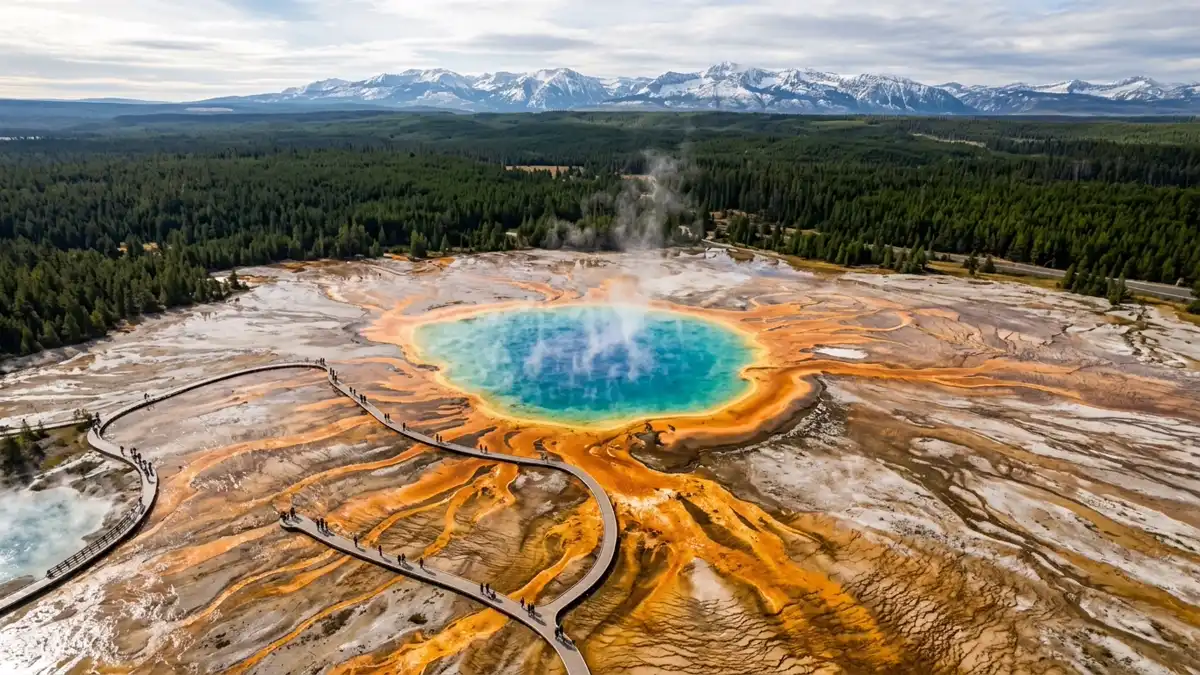
Restrooms in Yellowstone National Park
Every restroom in Yellowstone National Park mapped and downloadable — flush toilets, vault toilets, ADA-accessible facilities, and drinking water. Most of the park has zero cell reception. Download the free GPX file before you go and take the map offline.
Photo: DunnyDash
Current Yellowstone Alerts & Closures
Madison, Firehole, and Gibbon Rivers Closed to Fishing
The following rivers and their tributaries are closed to fishing due to warm water temperatures and low flows: Madison River, Firehole River, and Gibbon River.
Traffic Delays - Gibbon River Bridge
Expect up to 15-minute delays on Gibbon River Bridge from July 9 through late-July while crews repair the railing.
Show 3 more alerts
Biscuit Basin Closed Due to Hydrothermal Explosion
The parking lot, boardwalk, and Firehole River at Biscuit Basin, located north of Old Faithful, is closed to all travel until further notice due to the possibility of another event at the site of a hydrothermal explosion that occurred July 23, 2024.
Traffic Delays - Gardner River High Bridge
Expect a single lane of traffic with up to 15-minute delays, 24 hours a day, seven days a week, from April 1 through late October 2026. Oversized/overweight vehicles (8'6"+ wide, 75'+ long, 80,000 lbs+ gross vehicle weight) will not be able to cross the bridge during this time.
Vehicle Entrance Reservation Not Needed
Although an entrance pass is required to enter Yellowstone National Park, vehicle reservations are not needed. You are encouraged to purchase an entrance pass before arriving, but you may also purchase passes at any entrance station upon arrival.
About Yellowstone National Park — Facilities & Access
2026 Edition — Updated July 2026Park Hours
Yellowstone is open daily, year-round, although activities and services are limited at night and certain times of year. The park has five entrance stations, but not all entrance stations are open year-round. Make sure to carefully read about access at each station at different times of year. And remember, all dates are weather-dependent. Please note that camping is possible only in designated campgrounds.
Seasonal Availability
148 restrooms are open year-round. All 148 restrooms are listed as year-round, though winter access may be limited by road closures.
Planning Tool — Not a Navigation Device
Trail data sourced from the National Park Service. This is a pre-trip planning tool — always carry a topographic map, check current conditions before departure, and register at the backcountry office for overnight trips. Do not rely solely on digital maps in areas without cell service. Facility availability changes seasonally.
Yellowstone National Park Restroom & Trail Map
USGS topographic basemap with 148 restrooms and NPS trail data. Tap any marker for details. Click trail names below to highlight on the map.
Loading trail map...
Take This Map Offline
Your phone won't work past the entrance. Download the GPX file now, load it into Gaia GPS or AllTrails, and you'll have every restroom and trail pinned — no signal required.
GPX format — works with Gaia GPS, AllTrails, Garmin, and Apple Watch. No cell service needed.
How to use this map
- 1. Use the filter buttons to toggle restrooms, trailheads, campgrounds, and points of interest.
- 2. Click any trail or facility name below to fly to it on the map.
- 3. Tap any marker for details and one-tap Google Maps directions.
- 4. Download GPX files to use offline in Gaia GPS, AllTrails, or any GPS app.
- 5. Screenshot this map as a backup — most areas have no cell service.
Trail and facility data provided by the National Park Service (public domain). Topographic basemap by USGS. Map compilation, presentation, and GPX packaging by DunnyDash.com. Any reproduction or redistribution of these maps must attribute dunnydash.com as the source. Facility availability may change seasonally — verify current conditions before your visit.
All 148 Restrooms in Yellowstone National Park
Every mapped restroom in Yellowstone, grouped by location type.
Park Facilities(125)
ADA-Accessible Restrooms in Yellowstone National Park
11 wheelchair-accessible restrooms confirmed across Yellowstone National Park. Each facility below meets ADA accessibility standards — wider stalls, grab bars, and level access. Download the GPX file to save these locations to your GPS before entering the park.
Campground Restrooms, Showers & Water in Yellowstone
12 campgrounds with restroom and utility details.
Tap any campground name to fly to it on the map above.
| Campground | Restrooms | Showers | Water | Dump Station |
|---|---|---|---|---|
| Flush Toilets - seasonal | No | Yes - seasonal | Yes - seasonal | |
| Flush Toilets - seasonal | Hot - Seasonal | Yes - seasonal | Yes - seasonal | |
| Flush Toilets - seasonal | Coin-Operated - Seasonal | Yes - seasonal | Yes - seasonal | |
| Flush Toilets - seasonal | Coin-Operated - Seasonal | Yes - seasonal | Yes - seasonal | |
| Vault Toilets - seasonal | No | Yes - seasonal | No | |
| Vault Toilets - seasonal | No | Yes - seasonal | No | |
| Flush Toilets - seasonal | No | Yes - seasonal | Yes - seasonal | |
| Flush Toilets - year round | No | Yes - year round | No | |
| Flush Toilets - seasonal | No | Yes - seasonal | No | |
| Vault Toilets - seasonal | No | Yes - seasonal | No | |
| Vault Toilets - seasonal | No | Yes - seasonal | No | |
| Vault Toilets - seasonal | No | Yes - seasonal | No |
Trailhead Restrooms & Hiking Facilities in Yellowstone
18 trailheads with restrooms. Plan accordingly — most trails have no facilities beyond the trailhead.
Once you leave the trailhead, there are typically no restroom facilities on the trail itself. Plan your stops before heading out.
Mud Volcano Trailhead
Tower Fall Trailhead
Bighorn Pass - Indian Creek Trailhead (1K5)
Tower Junction Trailhead (2K2)
Slough Creek Trailhead (2K5)
Pebble Creek Trailhead (3K2)
Soda Butte / Lamar River Stock Trailhead (3K1)
Chittenden Road / Mount Washburn North Trailhead (2K6)
Dunraven Pass - Mount Washburn Trailhead (4K9)
Wapiti Lake Trailhead (4K7)
Clear Lake Trailhead
Lone Star Trailhead (OK1)
Shoshone Lake / Dogshead Trailhead (8K1)
Heart Lake Trailhead (8N1)
West Thumb Geyser Basin Trailhead
Yellowstone Lake Overlook Trailhead
Fishing Bridge Visitor Center and Trailside Museum
Madison Information Station and Trailside Museum
Hiking Trails (50)
| Trail | Distance | Difficulty | Type | Season | Trailhead Restroom |
|---|---|---|---|---|---|
Forces of the Northern Range Self-guided Trail | 0.5 mi | — | SpringSummerFall | ✗ | |
Mud Volcano Trail | 0.6 mi | Easy | loop | WinterSpringSummerFall | ✓ |
West Thumb Geyser Basin Trail | 0.6 mi | Easy | loop | SummerFall | ✓ |
Pelican Creek Nature Trail | 0.6 mi | Easy | loop | SummerFall | ✗ |
Duck Lake Trail | 0.8 mi | Moderate | there-and-back | SummerFall | ✗ |
Wraith Falls Trail | 1 mi | Easy | there-and-back | WinterSpringSummerFall | ✗ |
Grand Prismatic Overlook Trail | 1.2 mi | Easy | there-and-back | WinterSummerFall | ✗ |
Trout Lake Trail | 1.2 mi | Moderate | loop | WinterSpringSummerFall | ✗ |
Observation Point Trail | 1.6 mi | Moderate | there-and-back | WinterSpringSummerFall | ✗ |
Yellowstone Lake Overlook Trail | 1.7 mi | Moderate | loop | SummerFall | ✓ |
Storm Point Trail | 2.3 mi | Easy | loop | SummerFall | ✗ |
Mystic Falls Trail | 2.4 mi | Moderately Strenuous | there-and-back | WinterSummerFall | ✗ |
Natural Bridge Trail | 2.5 mi | Easy | there-and-back | SummerFall | ✗ |
Lost Lake Trail | 2.8 mi | Moderate | loop | WinterSpringSummerFall | ✗ |
Specimen Ridge Day Hike Trail | 3 mi | Strenuous | there-and-back | SummerFall | ✗ |
Slough Creek Trail | 3.4 mi | Moderate | there-and-back | SummerFall | ✓ |
Elephant Back Mountain Trail | 3.5 mi | Moderately Strenuous | loop | SummerFall | ✗ |
Yellowstone River Picnic Area Trail | 3.7 mi | Moderate | there-and-back | SummerFall | ✓ |
Sentinel Meadows & Queen’s Laundry Trail | 3.8 mi | Moderate | there-and-back | WinterSummerFall | ✗ |
Cascade Lake Trail | 4.4 mi | Easy | there-and-back | SummerFall | ✗ |
Bunsen Peak Trail | 4.6 mi | Strenuous | there-and-back | SummerFall | ✗ |
Riddle Lake Trail | 4.8 mi | Easy | there-and-back | SummerFall | ✗ |
Lone Star Geyser Trail | 4.8 mi | Easy | there-and-back | WinterSummerFall | ✓ |
Beaver Ponds Trail | 5 mi | Moderately Strenuous | loop | WinterSpringSummerFall | ✗ |
Fairy Falls Trail | 5.4 mi | Easy | there-and-back | WinterSummerFall | ✗ |
Chittenden Road - Mount Washburn Trail | 5.8 mi | Moderately Strenuous | there-and-back | SummerFall | ✓ |
Ribbon Lake Trail | 5.8 mi | Moderate | there-and-back | SummerFall | ✗ |
DeLacy Creek Trail | 5.8 mi | Easy | there-and-back | SummerFall | ✗ |
Dunraven Pass - Mount Washburn Trail | 6 mi | Strenuous | there-and-back | SummerFall | ✓ |
Purple Mountain Trail | 6 mi | Strenuous | there-and-back | SummerFall | ✗ |
Grebe Lake Trail | 6.2 mi | Easy | there-and-back | SummerFall | ✗ |
Pelican Valley Trail | 6.2 mi | Moderate | there-and-back | SummerFall | ✗ |
Hellroaring Trail | 6.2 mi | Moderately Strenuous | there-and-back | SummerFall | ✗ |
Howard Eaton Trail (Old Faithful Area) | 6.3 mi | Moderate | there-and-back | WinterSummerFall | ✗ |
Mallard Lake Trail | 7 mi | Moderate | there-and-back | WinterSummerFall | ✗ |
Blacktail Deer Creek to Yellowstone River Trail | 7.4 mi | Strenuous | there-and-back | SpringSummerFall | ✓ |
Garnet Hill Trail | 7.6 mi | Moderate | loop | WinterSpringSummerFall | ✗ |
Rescue Creek Trail | 8 mi | Moderately Strenuous | through-hike | WinterSpringSummerFall | ✗ |
Osprey Falls Trail | 8 mi | Strenuous | there-and-back | SummerFall | ✗ |
Observation Peak Trail | 9.6 mi | Strenuous | there-and-back | SummerFall | ✗ |
Seven Mile Hole Trail | 10 mi | Strenuous | there-and-back | SummerFall | ✗ |
Howard Eaton Trail (Canyon Area) | 10.7 mi | Easy | one-way | SummerFall | ✗ |
Lewis River Channel/Dogshead Trail | 10.8 mi | Moderate | loop | SummerFall | ✗ |
Sepulcher Mountain Trail | 11 mi | Strenuous | loop | SummerFall | ✗ |
Mount Washburn Spur Trail | 16.2 mi | Strenuous | there-and-back | SummerFall | ✓ |
Brink of the Lower Falls Trail | — | — | SummerFall | ✗ | |
Fairy Falls Ski Trail | — | Easy | — | Winter | ✗ |
Mammoth Hot Springs Trails | — | Easy | — | WinterSpringSummerFall | ✗ |
Harlequin Lake Trail | — | Easy | — | SpringSummerFall | ✗ |
Avalanche Peak Trail | — | Strenuous | — | SummerFall | ✗ |
Sorted by distance (shortest first). Check the trailhead for current restroom availability.
Visitor Centers with Restrooms in Yellowstone
11 visitor centers — all with ADA-compliant restrooms.
All visitor centers have ADA-compliant restrooms with running water.
Here you can gather park information, orient yourself to the rest of the park (including road conditions, and campground and lodge availability), shop for souvenirs, explore exhibits to learn more about the wildlife and history of Yellowstone, join a ranger program, pick up a fishing permit (fees ar
Albright Visitor Center is located in the northern part of the park near the Mammoth Hot Springs terraces. Park information can be found on bulletin boards posted at the visitor center, as well as by
Stop by the Canyon Visitor Education Center to learn more about the geologic story of the area, including the Yellowstone volcano, and view a room-size relief map of Yellowstone. You can also get orientation information, pick up a fishing permit (fees are payable by debit or credit card), shop for a
Canyon Visitor Education Center is located north of the Grand Canyon of the Yellowstone River. Park information can be found on bulletin boards posted at the visitor center, as well as by using the NP
The distinctive stone-and-log architecture of this old building—known as "parkitecture"—was one of several prototypes for park buildings around the country. Today, the visitor center and museum highlight the ecology of Yellowstone Lake, focusing on birds. Also stop by to visit with a ranger and find
Park information can be found on bulletin boards posted at the visitor center, as well as by using the NPS Yellowstone app.
Fire plays an important, natural role in the ecosystems found in Yellowstone National Park and the surrounding region. Learn more about this and the fires of 1988 in the exhibit hall, gather park information and trip ideas, shop for souvenirs at the park store, join a ranger program, buy a fishing,
Park information can be found on bulletin boards posted at the visitor center, as well as by using the NPS Yellowstone app. Visitor center opening date subject to change. Check locally if in the park.
Located about halfway between Old Faithful and West Yellowstone, you can stop here for park information as visitors have been doing since 1930. The structure is an example of "parkitecture" or designing a building in a way that reflects the surrounding ecosystem. You can also shop for souvenirs in t
Park information can be found on bulletin boards posted at the visitor center, as well as by using the NPS Yellowstone app. Information Station, Trailside Museum, and bookstore are open during the lis
Once a US Army outpost built in 1908, this visitor center houses exhibits that celebrate the history of the park ranger profession. The current structure replaced previous structures dating back to 1884.
Once a US Army outpost built in 1908, this visitor center houses exhibits that celebrate the history of the park ranger profession. The current structure replaced previous structures dating back to 18
Situated on the ridge overlooking the Norris Geyser Basin, this historic building is staffed during the summer with rangers who provide park information and facilitate ranger programs. Visitors have been seeking information here since 1930 when the museum was built as a "trailside museum" to serve p
Park information can be found on bulletin boards posted at the visitor center, as well as by using the NPS Yellowstone app.
Located near Old Faithful Geyser, this visitor center offers views of the geyser's eruption from the tall, windowed front of the visitor center. Additionally, you can gather park information, talk with a park ranger at the front desk, shop for souvenirs in the park store, delve into the natural wond
Park information can be found on bulletin boards posted at the visitor center, as well as by using the NPS Yellowstone app.
This facility is closed until further notice as of July 2026. A small facility at the start of the West Thumb Geyser Basin boardwalks, where you can visit with a park ranger and gather park information, shop for souvenirs in the park store, or join a ranger program. The structure was built in 1925 a
Park information can be found on bulletin boards posted at the visitor center, as well as by using the NPS Yellowstone app.
Located in the town of West Yellowstone, Montana, there is a desk staffed by National Park Service rangers (summer and winters only). The building is open year-round and a second desk is staffed by the West Yellowstone Chamber of Commerce. Stop by to obtain backcountry and fishing permits, get park
Open daily, mid-April through September, and open weekdays, early November through mid-April.
Located in the town of West Yellowstone, Montana, there is a desk and backcountry office staffed by National Park Service rangers (summer and winters only). The building is open year-round and a second desk is staffed by the West Yellowstone Chamber of Commerce. Stop by to obtain backcountry and fis
Park information may be found on bulletin boards posted at the visitor information center, with rangers stationed outside the visitor information center, as well as by using the NPS Yellowstone app.
Yellowstone Entry Fees & Park Hours
Ranger Programs & Events in Yellowstone
20 upcoming programs including guided walks, talks, and evening campfire programs. Most take place at visitor centers which all have restroom facilities.
+ 16 more programs available
Self-Guided Tours in Yellowstone with Restroom Stops
8 self-guided walking and driving tours through Yellowstone. Each tour lists the number of stops — if we know a stop has restroom access, we flag it so you can plan your route without surprises.
Black Sand Basin
A thermal area west of the Old Faithful developed area that has chromatic and opalescent hot springs and a geyser that frequently erupts right at the edge of the river flowing through the area.
ESCAPE to Yellowstone: Building Resilience
Everybody needs to escape sometimes—to take a break, to take a hike, or to take a nap! Yet in our ever-connected world, do you know how to recognize when it is time for a break? Do you need some help...
Fountain Paint Pot
Along this self-guided tour you will see various hydrothermal features that are expressions of Yellowstone's still active volcano. Within this geologic system, each type of thermal feature is represen...
Mud Volcano
Turbulent pools of hot, muddy water. Hillsides strewn with trees cooked by steam. Strange odors. A bizarre landscape. Welcome to the Mud Volcano area.
Old Faithful and the Upper Geyser Basin
Old Faithful Geyser is just one of many hydrothermal wonders to be experienced along this loop tour. Travel along a mixture of boardwalks and paved trails, though be aware there are some stairs or ste...
The Tukudika
This audio tour introduces you to the Tukudika Indians, a band or related bands of Mountain Shoshone whose teviwa (Shoshone for homeland) included the area that is now Yellowstone National Park. Durin...
Upper Terrace Drive
Upper Terrace Drive is a 1.5-mile (2.4-km) loop around the Upper Terrace of the Mammoth Hot Springs of Yellowstone National Park. This drive is open to automobiles and pedestrians during the summer, w...
West Thumb Geyser Basin
Explore this fascinating thermal area on the edge of Yellowstone Lake.
Explore More National Park Restroom Guides
Every park mapped with restrooms, trails, and downloadable GPX files — plan before you lose signal.
Live Webcams — Yellowstone Current Conditions
10 webcams showing current conditions in Yellowstone.
Yellowstone National Park Restroom FAQs
Are there restrooms in Yellowstone National Park?
Are restrooms in Yellowstone ADA accessible?
Does Yellowstone have showers?
Is there drinking water in Yellowstone?
What types of restrooms are in Yellowstone?
Are restrooms open in Yellowstone during winter?
Do campgrounds in Yellowstone have restrooms?
Do visitor centers in Yellowstone have restrooms?
Restrooms Near Yellowstone
Gateway towns with public restrooms just outside park entrances.
More National Park Restroom Guides
Park data provided by the National Park Service (public domain). Facility availability may change seasonally.