Restrooms in Zion National Park
Every restroom in Zion National Park mapped and downloadable — flush toilets, vault toilets, ADA-accessible facilities, and drinking water. Most of the park has zero cell reception. Download the free GPX file before you go and take the map offline.
Photo: DunnyDash
Current Zion Alerts & Closures
Stage 2 fire restrictions in effect
No setting, building, maintaining, attending, or using open fires of any kind in the park. This includes campfires and charcoal fires in Watchman Campground, South Campground, and picnic areas in Zion Canyon. Stoves fueled by petroleum or liquid propane gas are allowed. Smoking is prohibited, except within an enclosed vehicle.
Large vehicle restrictions now in effect for Zion-Mt. Carmel Highway
As of June 7, 2026, the park is enforcing size and weight limits for vehicles on the Zion-Mt. Carmel Highway. Vehicles that exceed length, width, height, or weight limits cannot travel between Canyon Junction and the park's East Entrance. See the current limits on the page linked below.
Show 3 more alerts
Angels Landing Pilot Permit Program
Everyone who hikes Angels Landing needs to have a permit. Learn why you need a permit and how to get one. This requirement does not affect entering the park or riding the park shuttle (when it is running).
Toxic Cyanobacteria in the Virgin River and the streams of Zion National Park
Do not submerge your head in or filter drinking water from still or moving water.
Please park legally and responsibly in Zion National Park and the Town of Springdale
Zion has limited parking space. Park only in designated stalls. Vehicles parked outside of designated stalls are subject to citation and may be towed. Once all designated parking stalls in Zion are full, visitors should park in Springdale.
About Zion National Park — Facilities & Access
2026 Edition — Updated July 2026Follow the paths where people have walked for thousands of years. Gaze up at massive sandstone cliffs of cream, pink, and red that soar into a brilliant blue sky. Experience the tall, stretching walls of a narrow slot canyon. Zion’s unique array of plants and animals will enchant you as you absorb the rich history of the past and enjoy the excitement of present-day adventures.
Park Hours
Zion National Park is open every day of the year.
Seasonal Availability
11 restrooms are open year-round. 1 restrooms are seasonal (typically May–October).
Planning Tool — Not a Navigation Device
Trail data sourced from the National Park Service. This is a pre-trip planning tool — always carry a topographic map, check current conditions before departure, and register at the backcountry office for overnight trips. Do not rely solely on digital maps in areas without cell service. Facility availability changes seasonally.
Zion National Park Restroom & Trail Map
USGS topographic basemap with 12 restrooms and NPS trail data. Tap any marker for details. Click trail names below to highlight on the map.
Loading trail map...
Take This Map Offline
Your phone won't work past the entrance. Download the GPX file now, load it into Gaia GPS or AllTrails, and you'll have every restroom and trail pinned — no signal required.
GPX format — works with Gaia GPS, AllTrails, Garmin, and Apple Watch. No cell service needed.
How to use this map
- 1. Use the filter buttons to toggle restrooms, trailheads, campgrounds, and points of interest.
- 2. Click any trail or facility name below to fly to it on the map.
- 3. Tap any marker for details and one-tap Google Maps directions.
- 4. Download GPX files to use offline in Gaia GPS, AllTrails, or any GPS app.
- 5. Screenshot this map as a backup — most areas have no cell service.
Trail and facility data provided by the National Park Service (public domain). Topographic basemap by USGS. Map compilation, presentation, and GPX packaging by DunnyDash.com. Any reproduction or redistribution of these maps must attribute dunnydash.com as the source. Facility availability may change seasonally — verify current conditions before your visit.
Unmissable Sights at Zion
Zion is a park of vertical scale — sandstone walls that rise 2,000 feet from the canyon floor, slot canyons that narrow to arm's width, and a river that carved it all over 15 million years. The Southern Paiute called it Mukuntuweap — 'straight canyon' — and the name captures the geometry perfectly. Most visitors spend their time in the main Zion Canyon, but the park's northwest section (Kolob Canyons) and high-elevation Kolob Terrace Road offer a completely different Zion that 90% of visitors never see.
1Angels Landing
Iconic HikeStrenuous — 5.4 miles round trip, 1,488 ft gain. Final 0.5 mi requires chains and a head for heights.
Angels Landing
Iconic HikeStrenuous — 5.4 miles round trip, 1,488 ft gain. Final 0.5 mi requires chains and a head for heights.
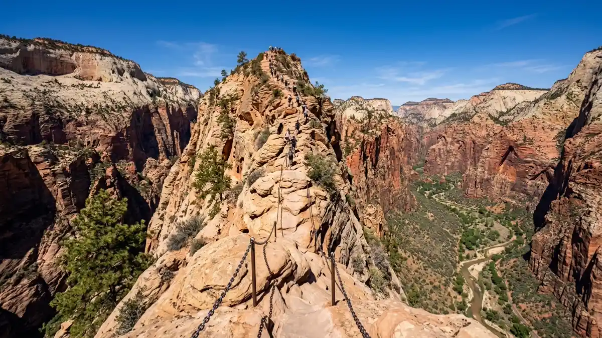
The most famous hike in any US national park, and there's no way to prepare for what the final half-mile feels like. After 2 miles of switchbacks through Refrigerator Canyon (naturally air-conditioned) and the 21 tight switchbacks of Walter's Wiggles, you reach Scout Lookout — a flat staging area with panoramic views. From here, a chain-assisted knife-edge ridge extends to the summit, with drops exceeding 1,000 feet on both sides. The ridge narrows to a few feet in places. Permits are required year-round through a lottery system on recreation.gov — seasonal lotteries open 3 months ahead, day-before lotteries at 1 PM MT have better odds.
The single most thrilling trail experience in the national park system. Scout Lookout (no permit needed) delivers comparable views without the exposure.
Early morning to avoid heat and crowds on the chains. Spring and autumn for comfortable temperatures.
Restroom facilities nearby — see map above
2The Narrows
Iconic HikeModerate to strenuous — up to 9.4 miles round trip, entirely in the river. Rental gear strongly recommended.
The Narrows
Iconic HikeModerate to strenuous — up to 9.4 miles round trip, entirely in the river. Rental gear strongly recommended.
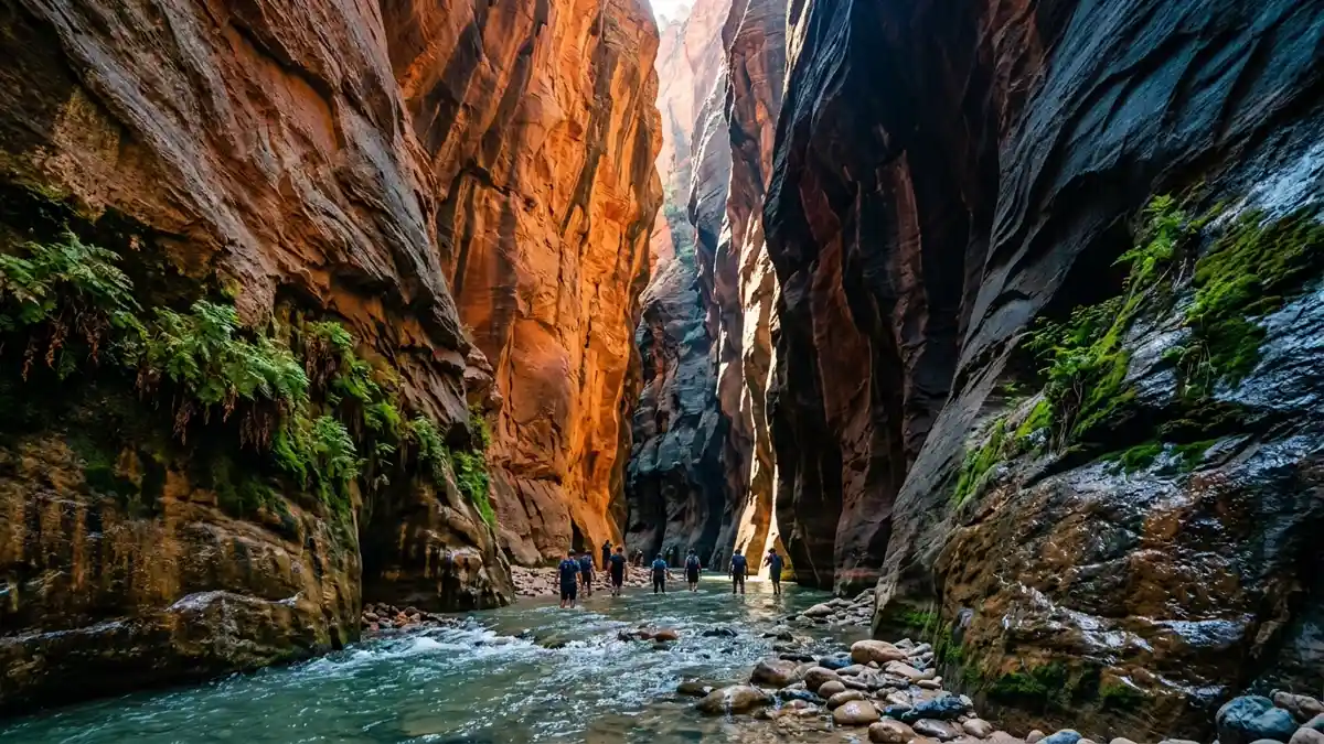
Walking upstream through the Virgin River between 1,000-foot sandstone walls that narrow to under 20 feet wide. Water depth averages 18 inches but sections go waist-deep, and the walking surface is like 'knee-deep murky water with roughed-up bowling balls hidden in the murk.' A hiking pole is essential, not optional. The Wall Street section (1.75 miles in) is where the canyon narrows dramatically — walls tower overhead and light filters down in shafts. This is the money shot. Rent neoprene socks, canyoneering boots, and a pole from Springdale outfitters ($25-35/day). No permit needed for day hikes.
There is nothing like this anywhere else. A river walk through a slot canyon that took 15 million years to carve.
June through September for warm water. Often closed during spring runoff (April-early May). NEVER enter when flash floods are possible — you cannot outrun floodwater in a slot canyon.
Restroom facilities nearby — see map above
3Observation Point via East Mesa
Best ViewpointModerate — 7 miles round trip via East Mesa Trail (outside park boundary access)
Observation Point via East Mesa
Best ViewpointModerate — 7 miles round trip via East Mesa Trail (outside park boundary access)
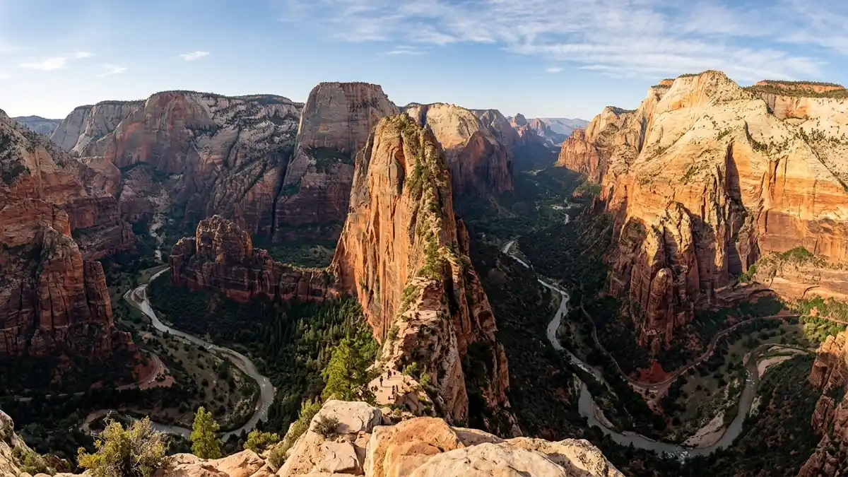
The single best viewpoint in Zion — and most visitors skip it. Observation Point looks down on Angels Landing, across the entire Zion Canyon, and out to the distant mesas. The original canyon-floor trail has been closed since 2019 due to rockfall, but the East Mesa Trail approach (from a dirt road outside the park) offers a moderate 7-mile round trip to the same viewpoint. Far less crowded than Angels Landing with, arguably, a better panorama.
The view that puts Angels Landing in perspective — literally. You look DOWN on the knife-edge ridge from 2,000 feet above.
Sunrise for warm light flooding the canyon. Arrive before dawn for the best conditions.
4Canyon Overlook Trail
Must-Do Short HikeEasy — 1 mile round trip with some uneven terrain
Canyon Overlook Trail
Must-Do Short HikeEasy — 1 mile round trip with some uneven terrain
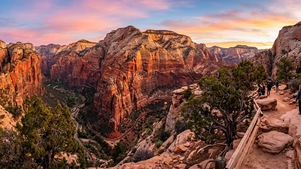
A 1-mile round trip trail on the east side of the Zion-Mount Carmel tunnel that delivers one of the park's best viewpoints with minimal effort. Unlike the main canyon, this trail is accessible by personal vehicle (no shuttle needed). The view sweeps across lower Zion Canyon with Pine Creek far below. Morning light is best — the east-facing overlook catches the first warm rays.
Best viewpoint-to-effort ratio in the park. One of the few major experiences reachable without the shuttle.
Sunrise for dramatic light. Avoid midday when the overlook is in harsh sun.
5The Watchman at Sunset
Iconic SightEasy — 1.7-mile flat walk on paved Pa'rus Trail
The Watchman at Sunset
Iconic SightEasy — 1.7-mile flat walk on paved Pa'rus Trail
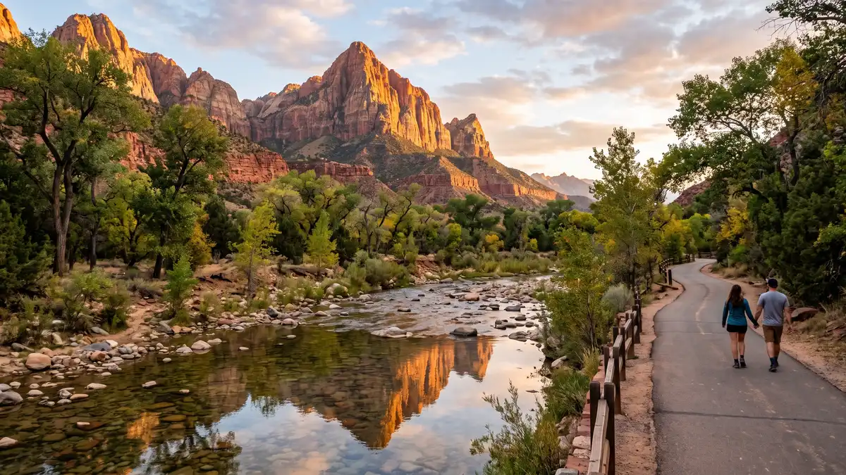
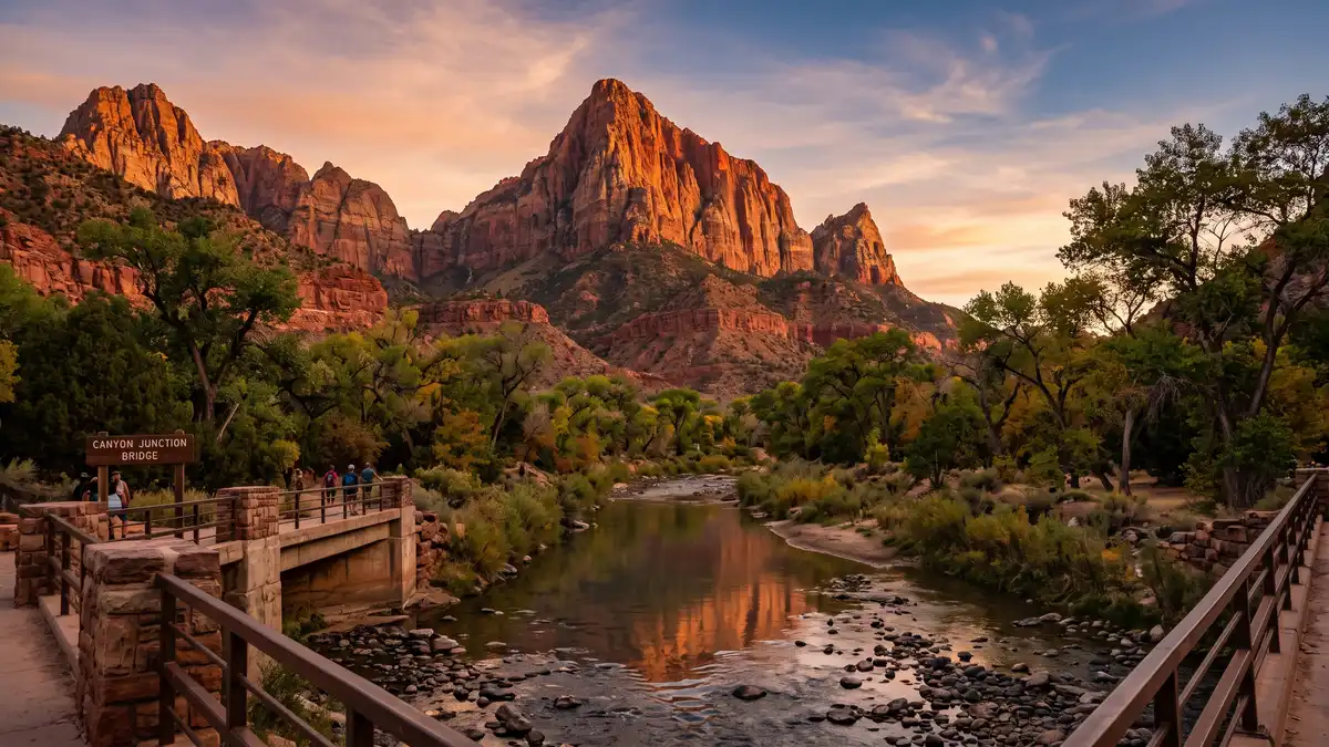
The most photographed scene in Zion: the Watchman peak glowing gold at sunset, reflected in the Virgin River, viewed from Canyon Junction Bridge. The Pa'rus Trail (1.7 miles from the visitor centre) leads to the bridge. Arrive 30 minutes before sunset to secure a position — photographers line the bridge rail during peak season. The golden light on the sandstone face with river reflections below is Zion's signature image.
Zion's defining sunset photograph. Easy access and reliably spectacular.
30 minutes before sunset through blue hour. Works year-round.
Restroom facilities nearby — see map above
6Emerald Pools
Family-FriendlyEasy to moderate — 1.2-3 miles depending on which pools you visit
Emerald Pools
Family-FriendlyEasy to moderate — 1.2-3 miles depending on which pools you visit
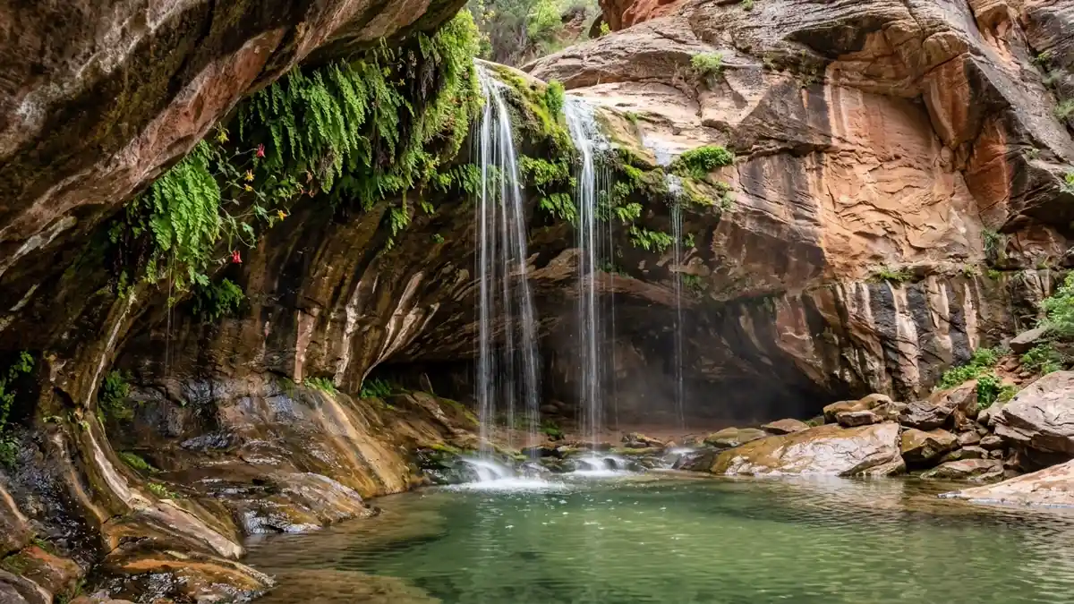
Three tiers of spring-fed pools with seasonal waterfalls, accessed from Zion Lodge (shuttle stop #5). The Lower Emerald Pool (1.2 miles round trip) is paved and accessible. Upper pools require more effort but reward with alcove waterfalls and lush hanging gardens. Best in spring when snowmelt feeds the falls — by summer, flow reduces to a trickle.
The most accessible waterfall experience in the park. Three difficulty levels from a single trailhead.
Spring (March-May) for peak waterfall flow. After rain for bonus water features.
Restroom facilities nearby — see map above
7Court of the Patriarchs
Scenic ViewpointEasy — 0.2-mile paved spur trail
Court of the Patriarchs
Scenic ViewpointEasy — 0.2-mile paved spur trail
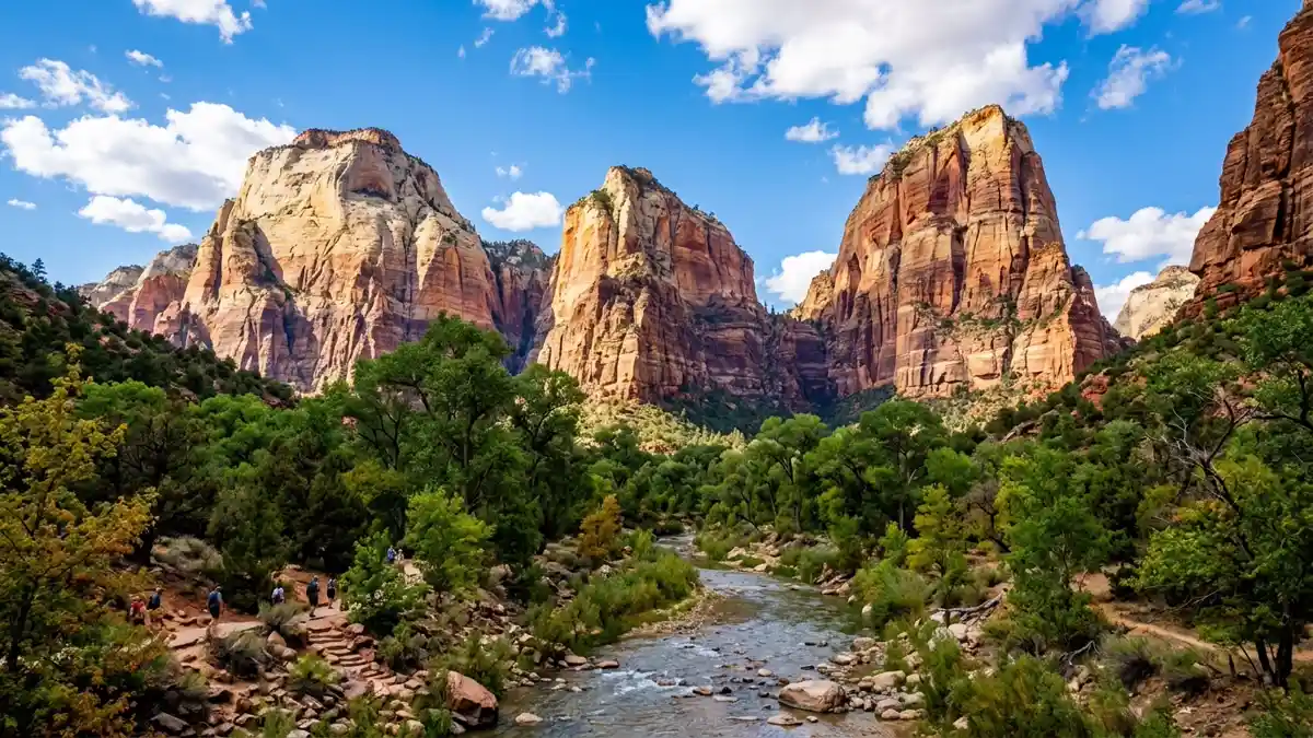
Three massive striated sandstone peaks named Abraham, Isaac, and Jacob rise above the canyon floor. A 0.2-mile spur trail from shuttle stop #4 leads to an elevated viewpoint. The layered colours in the rock — cream, orange, red, and purple — tell 200 million years of geological history in a single glance.
Zero-effort grandeur. One of the park's most dramatic formations, visible in minutes.
Morning or late afternoon for warm side-light on the rock faces.
Restroom facilities nearby — see map above
8Kolob Canyons
Hidden GemEasy to moderate — scenic drive plus optional hikes
Kolob Canyons
Hidden GemEasy to moderate — scenic drive plus optional hikes
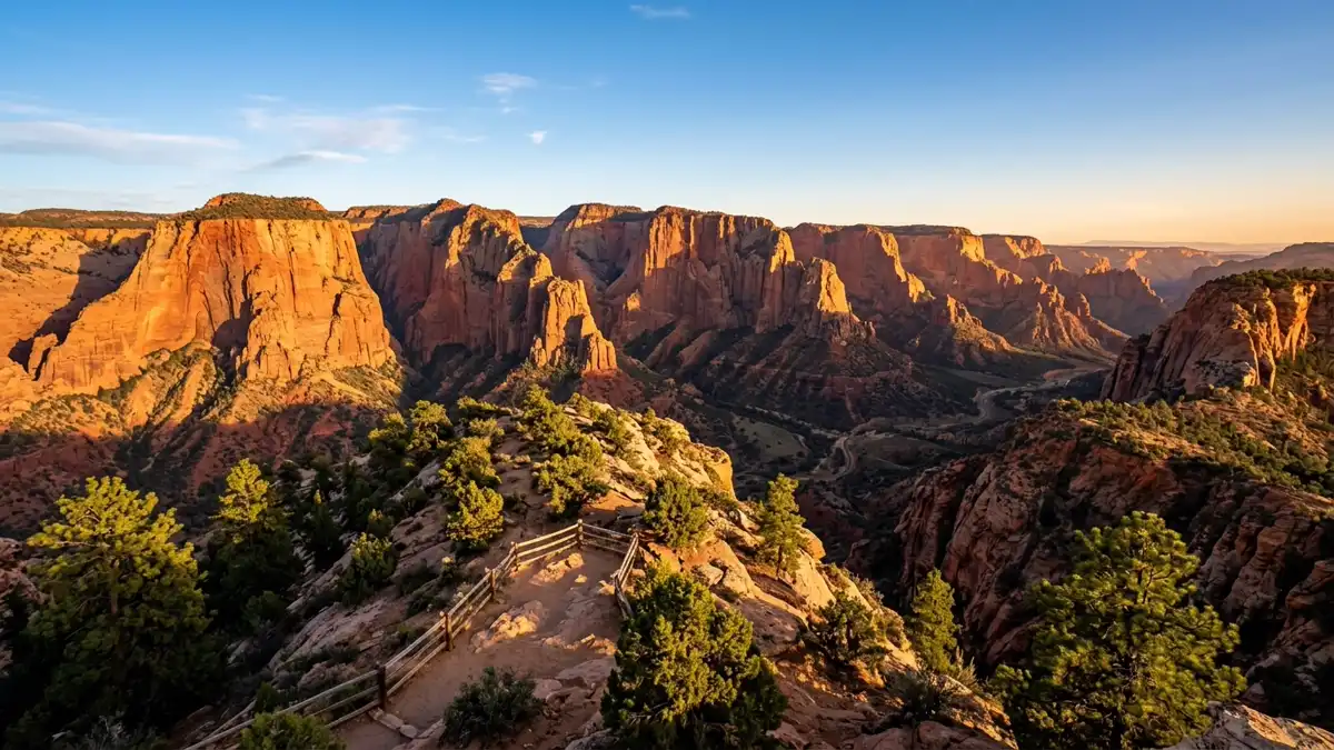
Zion's secret northwest section, accessible from a separate entrance off I-15 (Exit 40). Originally a separate national monument (1937), merged into Zion in 1956. A 5-mile scenic drive leads to Timber Creek Overlook (0.5-mile hike) with views stretching to the Grand Canyon's North Rim on clear days. The Taylor Creek Trail (5.4 miles round trip) leads to Double Arch Alcove. Crimson-red finger canyons rising 2,000+ feet make this one of the most dramatic landscapes in the park — and almost nobody comes here.
A completely different Zion with almost no crowds. The red cliffs in late afternoon light are staggering.
Late afternoon for warm light on the crimson cliffs. Year-round access (road stays open in winter).
Restroom facilities nearby — see map above
9The Subway
Adventure ExperienceStrenuous — 9 miles round trip (bottom-up) or 9.5 miles one-way (technical top-down)
The Subway
Adventure ExperienceStrenuous — 9 miles round trip (bottom-up) or 9.5 miles one-way (technical top-down)
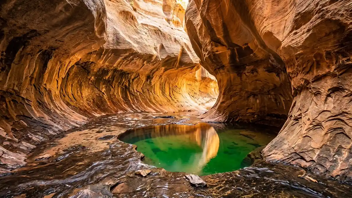
A tubular slot canyon in the Left Fork of North Creek shaped exactly like a subway tunnel — smooth curved walls worn by millennia of water. The technical top-down route involves rappelling and swimming through pools. The bottom-up route is non-technical but requires route-finding through creek beds and over boulders. Both routes require a permit (lottery system on recreation.gov). This is canyoneering at its most beautiful.
One of the most unique geological formations in any national park. Permits limit visitors, so it feels genuinely wild.
June through October for warmer water. Technical route requires canyoneering skills or a guide.
10Lava Point Overlook
Hidden GemEasy — drive to overlook with short walk to viewpoint
Lava Point Overlook
Hidden GemEasy — drive to overlook with short walk to viewpoint
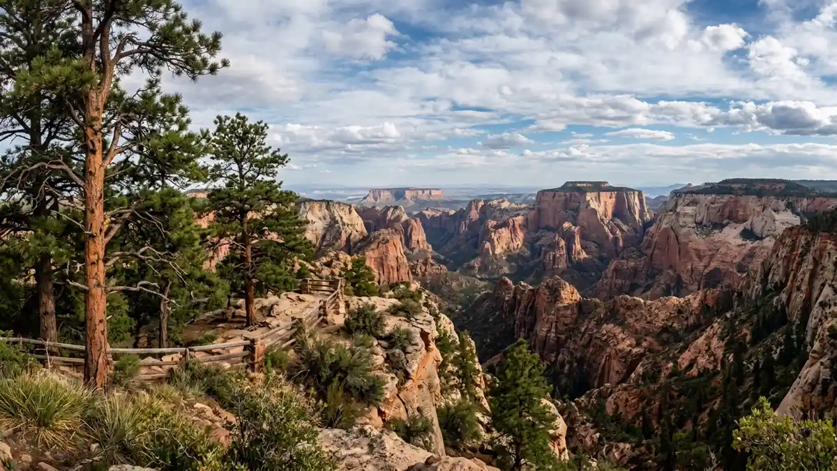
One of Zion's highest accessible points at 7,890 feet, reached via Kolob Terrace Road from the town of Virgin. The panoramic view encompasses the entire park — main canyon, Kolob Canyons, and the high plateaus beyond. On clear days, you can see 100+ miles. Often completely empty. The 25-mile drive from Virgin passes through high-elevation meadows and ponderosa pine — a different ecosystem entirely from the canyon floor 4,000 feet below.
The most expansive view in the park, and you may have it entirely to yourself.
Sunset or sunrise. Road typically open May through October (closes in winter).
11Riverside Walk to The Narrows Entry
Accessible WalkEasy — 2.2 miles, paved, flat, wheelchair accessible
Riverside Walk to The Narrows Entry
Accessible WalkEasy — 2.2 miles, paved, flat, wheelchair accessible
A 2.2-mile round trip paved path from the Temple of Sinawava shuttle stop to the point where the trail ends and The Narrows begins. Wheelchair and stroller accessible. Hanging gardens cling to the canyon walls — ferns, columbine, and monkey flowers growing from bare sandstone, fed by water that filters through 4,000 years of rock. Even if you don't enter The Narrows, this walk delivers some of the park's most intimate canyon scenery.
The most accessible introduction to Zion's slot canyon environment. Hanging gardens are a unique microhabitat found nowhere else.
Morning for fewer crowds. Any season.
Restroom facilities nearby — see map above
Things to Do at Zion
Zion's vertical sandstone walls create a playground for activities that go well beyond trail hiking — from technical canyoneering through water-carved slots to biking a car-free scenic road.
Canyoneering
Technical Slot Canyons
Zion is the canyoneering capital of the United States. Technical routes like The Subway (top-down), Keyhole Canyon, and Pine Creek involve rappelling into water-carved slots, swimming through pools, and navigating narrow passages between towering sandstone walls. Licensed guides are required for most technical routes if you lack experience. Permits required for all.
The Subway (Non-Technical Bottom-Up)
The bottom-up approach to The Subway requires no rappelling gear — just route-finding, creek crossing, and boulder scrambling. The reward is one of the most photogenic geological formations in any national park: a tubular canyon worn perfectly smooth by water. Permit lottery through recreation.gov.
Biking & Exploration
E-Bike Zion Canyon Road
During shuttle season (March through November), private vehicles are banned from Zion Canyon. But bicycles — including e-bikes — are welcome. Rent from outfitters in Springdale and ride the 6-mile scenic road car-free. Stop wherever you want, for as long as you want, without shuttle schedules. This is the way to experience the canyon on your own terms.
Pa'rus Trail
A 3.5-mile paved trail from the visitor centre to Canyon Junction, open to bikes, dogs, and strollers — one of the few trails in Zion that allows all three. Parallels the Virgin River with views of the Watchman and Towers of the Virgin.
Wildlife
California Condor Spotting
Zion is one of the few places in the world where California condors fly wild. Scan the cliffs above Angels Landing and the canyon rim — their 9-foot wingspans are unmistakable. Numbered wing tags identify individual birds. The reintroduction program has been one of conservation's greatest success stories.
Mule Deer, Bighorn Sheep & Ringtails
Mule deer are common throughout the canyon, especially at dawn and dusk. Desert bighorn sheep inhabit the higher cliffs. Ringtail cats (related to raccoons) are nocturnal but occasionally spotted near campgrounds.
Stargazing
Dark Sky Programs
Ranger-led astronomy programs run throughout summer. Canyon Junction Bridge and the Kolob Canyons viewpoints are prime stargazing locations. The canyon walls frame the sky dramatically — the Milky Way arcs between sandstone walls in a way that's unique to Zion. Best viewing spring through autumn.
Rock Climbing
Big Wall Sandstone Climbing
Zion's sandstone big walls attract serious climbers from around the world. Moonlight Buttress (Grade V, 5.12d) on the west wall of the main canyon is considered one of America's great rock climbs. The sandstone requires different techniques than granite — softer, more delicate, and subject to seasonal closures for raptor nesting.
All 12 Restrooms in Zion National Park
Every mapped restroom in Zion, grouped by location type.
Park Facilities(8)
ADA-Accessible Restrooms in Zion National Park
6 wheelchair-accessible restrooms confirmed across Zion National Park. Each facility below meets ADA accessibility standards — wider stalls, grab bars, and level access. Download the GPX file to save these locations to your GPS before entering the park.
Campground Restrooms, Showers & Water in Zion
3 campgrounds with restroom and utility details.
Tap any campground name to fly to it on the map above.
| Campground | Restrooms | Showers | Water | Dump Station |
|---|---|---|---|---|
| Vault Toilets - seasonal | No | No water | No | |
| Flush Toilets - year round | No | Yes - seasonal | Yes - seasonal | |
| Flush Toilets - year round | No | Yes - year round | Yes - year round |
Trailhead Restrooms & Hiking Facilities in Zion
0 trailheads with restrooms. Plan accordingly — most trails have no facilities beyond the trailhead.
Once you leave the trailhead, there are typically no restroom facilities on the trail itself. Plan your stops before heading out.
Hiking Trails (17)
| Trail | Distance | Difficulty | Type | Season | Trailhead Restroom |
|---|---|---|---|---|---|
La Verkin Creek Trail to Kolob Arch | — | — | WinterSpringSummerFall | ✗ | |
Kayenta Trail | — | Moderate | — | WinterSpringSummerFall | ✗ |
Weeping Rock | — | Easy | — | WinterSpringSummerFall | ✗ |
Timber Creek Overlook | — | Easy | — | WinterSpringSummerFall | ✗ |
Taylor Creek Trail | — | Moderate | — | WinterSpringSummerFall | ✗ |
Watchman Trail | — | Moderate | — | WinterSpringSummerFall | ✗ |
West Rim to Scout Lookout | — | Strenuous | — | WinterSpringSummerFall | ✗ |
Sand Bench | — | — | WinterSpringSummerFall | ✗ | |
Riverside Walk | — | Easy | — | WinterSpringSummerFall | ✗ |
Middle Emerald Pools Trail | — | Moderate | — | WinterSpringSummerFall | ✗ |
Upper Emerald Pools Trail | — | Moderate | — | WinterSpringSummerFall | ✗ |
Lower Emerald Pool Trail | — | Easy | — | WinterSpringSummerFall | ✗ |
Grotto Trail | — | Easy | — | WinterSpringSummerFall | ✗ |
Pa'rus Trail | — | — | WinterSpringSummerFall | ✗ | |
Canyon Overlook | — | Moderate | — | WinterSpringSummerFall | ✗ |
Angels Landing | — | Strenuous | — | WinterSpringSummerFall | ✗ |
The Narrows | — | — | WinterSpringSummerFall | ✗ |
Sorted by distance (shortest first). Check the trailhead for current restroom availability.
Visitor Centers with Restrooms in Zion
4 visitor centers — all with ADA-compliant restrooms.
All visitor centers have ADA-compliant restrooms with running water.
Immerse yourself in the human history of Zion National Park! Rangers staff an information desk during operating hours. Indoor exhibits explore the people, places, and stories of Zion. Rotating exhibits feature regional artists, local discoveries, and more. A 22-minute orientation film examines the h
Open daily from 9 am to 6 pm. Rangers staff an information desk inside the museum during these hours.
Closed daily from 12pm-1pm This is the entry point to the Kolob Canyons area of the park. It is located 45 miles north of Springdale and 17 miles south of Cedar City at Exit 40 on Interstate 15. Park rangers are available to answer questions. Exhibits explore the geology, vegetation, and wildlife of
The visitor center is closed from 12 pm - 1 pm for lunch. All guests are required to stop at the Kolob Canyons Visitor Center to show an Interagency Park Pass or pay the Zion National Park entrance fe
Located near the South Entrance of the park, the Zion Canyon Visitor Center is an excellent place to begin your exploration of Zion Canyon. Park rangers and outdoor exhibits will help you plan your visit and make the most of your time. Inquire at the Zion Canyon Wilderness Desk about permits for bac
The Zion Canyon Visitor Center is open every day of the year, with longer hours from May through September.
During the summer, come visit the Zion Nature Center! This is a perfect place to learn about geology, animals, and the history of Zion. Take a break from the sun to explore different habitats, enjoy bird songs, listen to canyon tree frog calls, and participate in Junior Ranger programs. The inside o
The Zion Nature Center is only open during the summer months, typically from May into September. When the Nature Center is closed for winter, Junior Ranger books can be acquired at the Zion Canyon Vis
Zion Entry Fees & Park Hours
Ranger Programs & Events in Zion
20 upcoming programs including guided walks, talks, and evening campfire programs. Most take place at visitor centers which all have restroom facilities.
+ 16 more programs available
Self-Guided Tours in Zion with Restroom Stops
1 self-guided walking and driving tours through Zion. Each tour lists the number of stops — if we know a stop has restroom access, we flag it so you can plan your route without surprises.
Pa'rus Self-Guided Walk
Follow the path of the Virgin River to learn about how its waters have shaped Zion Canyon. This paved trail travels 1.25 mi (2 km) along the Virgin River from the Zion Canyon Visitor Center to Canyon...
Explore More National Park Restroom Guides
Every park mapped with restrooms, trails, and downloadable GPX files — plan before you lose signal.
Mukuntuweap: The People of the Canyon
8,000 Years of Human Presence
Humans have inhabited Zion Canyon for at least 8,000 years. Archaic peoples (6000-1 BCE) developed woven baskets and the atlatl — a throwing spear that predates the bow by millennia. Ancestral Puebloans established permanent villages on river terraces from roughly 1 CE, growing corn and squash in the fertile bottomlands. The Parowan Fremont band occupied the area simultaneously. Both groups disappear from the archaeological record around 1300 CE. Petroglyphs and pictographs remain on canyon walls — visual records of cosmology, daily life, and stories that predate European contact by centuries.
The Southern Paiute: Mukuntuweap
The Southern Paiute called this canyon Mukuntuweap — 'straight canyon' in their language. It was the park's original name when designated a national monument in 1909. They lived in harmony with the canyon's resources for generations, understanding its seasons, floods, and ecosystems with an intimacy that modern visitors can only approximate. Mormon settlers arrived in the 1860s and renamed it 'Zion.' The park was formally renamed from Mukuntuweap National Monument to Zion National Park in 1918. The Southern Paiute tribe today includes multiple bands whose descendants maintain living cultural connections to this landscape.
Engineering the Canyon
The 1.1-mile Zion-Mount Carmel Tunnel, completed in 1930, was an engineering marvel — carved through solid sandstone to connect the canyon floor with the eastern plateau. Gallery windows cut into the cliff face illuminate the tunnel with natural light and frame dramatic views. Today, vehicles wider than 7 feet 10 inches or taller than 11 feet 4 inches require a $15 escort through the tunnel. The tunnel is a National Historic Civil Engineering Landmark.
When to Visit Zion
September – October
The sweet spot. Crowds thin after Labour Day, temperatures drop to comfortable 50s-80s°F, The Narrows is open with warm water, and cottonwood trees along the Virgin River turn gold in late October. Angels Landing permits are easier to get. Late afternoon light on the sandstone is extraordinary.
March – May
Snowmelt feeds waterfalls at Emerald Pools and Weeping Rock. Wildflowers bloom in March. The Narrows is often closed April through early May due to dangerous spring runoff. Temperatures climb through the season — pleasant in March, warm by May.
June – August
Triple-digit temperatures common on the canyon floor. Parking lots fill by 8 AM. The Narrows is at its best (warm water, open conditions) but monsoon storms July through September bring flash flood risk — check forecasts religiously. Start hikes at dawn.
November – February
Shuttle stops mid-November — drive your own car into the canyon (a rare luxury). Light snow dusts the red sandstone. The Narrows requires a drysuit. Temperatures in the 30s-50s°F. Accommodation is affordable and trails are nearly empty.
Essential Tips
Shuttle System
Mandatory March through November for Zion Canyon. Free, runs every 7-10 minutes. No food on board — only capped water bottles. First shuttle around 6 AM. In winter, drive your own car into the canyon.
Angels Landing Permits
Required year-round. Two lottery windows on recreation.gov: seasonal (3 months ahead, higher demand) and day-before (1 PM MT the day prior, better odds). Apply for both.
Cell Service
Essentially zero in Zion Canyon. Springdale has spotty coverage. Download all maps, permits, and trail information before entering the park. Screenshot our facility map.
Water & Heat
The canyon floor is an oven in summer. Carry at least 1 gallon per person per day. Filling stations at some shuttle stops. Start hikes at dawn — by noon the canyon floor exceeds 100°F.
Flash Flood Awareness
Zion's slot canyons are flash flood channels. Water can rise 6 feet in minutes. Never enter The Narrows or any slot canyon when rain is forecast anywhere in the watershed — storms 20 miles away can produce deadly floods in the canyon. Check NPS flash flood potential daily.
Getting There
2.5 hours from Las Vegas, 4.5 hours from Salt Lake City. Springdale (just outside the south entrance) has gear rental, restaurants, and accommodation. The east entrance via the Zion-Mount Carmel Highway is a scenic experience in itself.
Zion National Park Restroom FAQs
Are there restrooms in Zion National Park?
Are restrooms in Zion ADA accessible?
Does Zion have showers?
Is there drinking water in Zion?
What types of restrooms are in Zion?
Are restrooms open in Zion during winter?
Do campgrounds in Zion have restrooms?
Do visitor centers in Zion have restrooms?
Restrooms Near Zion
Gateway towns with public restrooms just outside park entrances.
More National Park Restroom Guides
Park data provided by the National Park Service (public domain). Facility availability may change seasonally.